
Find Your House
The PA Flood Risk Tool is a quick and easy way to check your flood risk.
To use the tool, go to http://pafloodrisk.psu.edu
You will see a map of Pennsylvania with an aerial photo background.
Application Functionality
The Zoom In/Zoom Out (+ and - buttons) are in the upper left corner. These allow you to zoom in to or out from a specific area of interest simply by clicking the + or - buttons.
The Navigation bar is along the left side of the application. The Navigation bar allows users to select base maps, layers, and switch modes from Public to Advanced. There is also a Home button that will reset the map to the statewide view.
The Address and County Search bar is across the top of the application.
Find Your Location
To find a specific location, you can type in your address in the Address search bar or zoom to a point on the map by clicking the + button in the upper left corner of the application. You may also zoom to a specific county by selecting the desired county in the County search drop down list in the upper right corner of the application.

Your Location Details
Once you click on the location you are interested in, you will see a red X on your point. If the red X is not exactly in the spot you want, you can readjust the point by clicking on the exact location you are interested in.
Flood Risk Summary Dashboard
Your Flood Risk Summary will appear in a blue box. This contains information you need about your location of interest including providing access to your Flood Risk Report and your DFIRM.
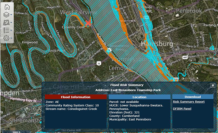
Flood Information: Effective Flood Zone, Flood Depth, Community Rating System Class, and Stream Name (where available). Your risk will be labled either Green (no/low risk); Yellow (low risk); or Red (high risk).
Location: Parcel Number (where available), HUC8, Elevation (feet), County, and Municipality.
Download: A link to download your Risk Summary Report in PDF format and a link to download your DFIRM Panel, also in PDF format.
Viewing and Downloading Your Report and DFIRM
To view and/or download your Risk Summary Report, just click on the words Risk Summary Report on the Dashboard. This will generate a PDF file that you can download and read using Adobe Acrobat Reader.
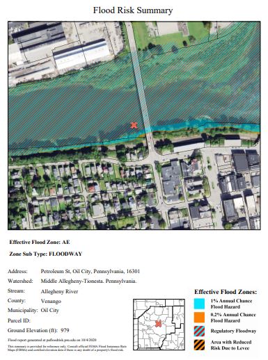
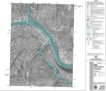
To download your DFIRM, just click on the Download link. This will allow you to download the DFIRM in PDF format to your computer. You can read the DFIRM using Adobe Acrobat Reader.
Available Layers
To turn on a data layer, just click on its name. The button will turn from light blue (OFF) to darker blue (ON). To turn the layer off, just click it again. You can also use the slider at the bottom of the button to set the transparency for the layer. Available layers include:
Public Mode: The data layers available in the Public Mode include: Effective Flood Hazard Zones and a link to the FEMA Changes Since Last FIRM (CSLF) Viewer.
Advanced Mode: The data layers in Advanced Mode include: Effective Flood Hazard Zones, Preliminary Flood Hazard Zones, Approximate Zone A Flood Water Surface Elevations Cross Sections, Zone A Flood Water Surface Elevations Cross Sections, CRS Communities, FIRM Panels, LOMAs, LOMRs, Approximate Zone A Water Surface Elevations, 1% Depth Grids, HUC 8, and a link to the FEMA CSLF Viewer.
Change Basemaps
To turn on a basemap layer, just click on its name. The button will turn from light blue (OFF) to darker blue (ON). To turn the basemap layer off, just click it again. You can also use the slider at the bottom of the button to set the transparency for the layer. Available layers include:
Public Mode: Basemaps include NAIP leaf on 2019 imagery, Bing Streets, Bing Imagery.
Advanced Mode: Basemaps include NAIP leaf on 2019 imagery, PEMA 2018-2020 imagery, 1993 imagery, 1999 imagery, black and white 1993-1995 imagery, Bing Streets, Bing Imagery, USGS Topo, ESRI Topo, ESRI Streets, NAIP 2017.
Map Legend
The Map Legend shows the colors and symbology for the flood related layers including 1% chance annual flood hazard, regulatory floodway, 0.2% annual chance flood hazard, and area with reduced risk due to levee.
DISCLAIMER: The user of this information should always consult official FEMA flood maps and certified elevation data if there is any doubt of a property's flood risk. Please consult with your local, county, and/or community floodplain administrator for availability of official DFIRMs in your county. These maps are available online at http://www.msc.fema.gov . Use constitutes acceptance of disclaimer terms.